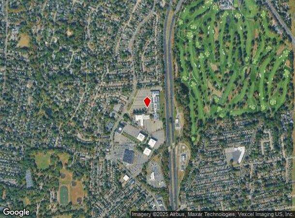
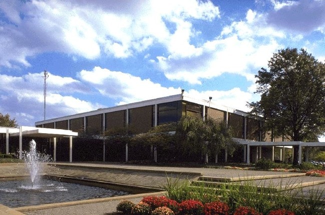
Property Record
1515 Broad St, Bloomfield, NJ 07003


NEARBY LISTINGS FOR SALE OR LEASE
Property Detail
1515 Broad St
Newark, NJ-PA
14.268 AC.
02-01231-0000-00052-02
Essex
Vacantlandnec
New Jersey
X
52.2
34031C0258G
14.27 AC
2023
Bloomfield/GSP
2025
Northern New Jersey
014800
DEMOGRAPHICS near 1515 Broad St
1 Mile
3 Mile
5 Mile
2024 Total Population
17,355
204,904
628,109
2029 Population
17,159
200,984
612,261
Pop Growth 2024-2029
(1.13%)
(1.91%)
(2.52%)
Average Age
41
40
40
2024 Total Households
6,220
75,076
227,108
HH Growth 2024-2029
(1.30%)
(2.03%)
(2.62%)
Median Household Inc
$154,678
$100,528
$82,190
Avg Household Size
2.70
2.60
2.70
2024 Avg HH Vehicles
2.00
2.00
2.00
Median Home Value
$478,918
$458,161
$442,364
Median Year Built
1950
1952
1953
Nearby Places
Map Layers
Map Styles
 Street
 Aerial
- Restaurants
- Banks
- Shops
- Fitness
- Groceries
PUBLIC TRANSPORTATION
COMMUTER RAIL
Upper Montclair (Montclair-Boonton Line - NJ Transit Commuter Rail (NJ Transit))
DRIVE
WALK
Distance
Upper Montclair (Montclair-Boonton Line - NJ Transit Commuter Rail (NJ Transit))
4 min
1.7 mi
Mountain Avenue (Montclair-Boonton Line - NJ Transit Commuter Rail (NJ Transit))
DRIVE
WALK
Distance
Mountain Avenue (Montclair-Boonton Line - NJ Transit Commuter Rail (NJ Transit))
4 min
1.9 mi
AIRPORT
Newark Liberty International
DRIVE
WALK
Distance
Newark Liberty International
20 min
16.6 mi
LaGuardia
DRIVE
WALK
Distance
LaGuardia
40 min
23.1 mi
John F Kennedy International
DRIVE
WALK
Distance
John F Kennedy International
48 min
31.1 mi
Freight Ports
Port Newark Container Terminal
DRIVE
WALK
Distance
Port Newark Container Terminal
25 min
15.9 mi
Nearby Properties
Address
Land Use
TOTAL SIZE
Lot Size
Zoning
Address
Land Use
TOTAL SIZE
Lot Size
Zoning
5 AC
H
Address
Land Use
TOTAL SIZE
Lot Size
Zoning
28.33 AC
Address
Land Use
TOTAL SIZE
Lot Size
Zoning
1,589 SF
R4
Address
Land Use
TOTAL SIZE
Lot Size
Zoning
12.54 AC
OPRP
Address
Land Use
TOTAL SIZE
Lot Size
Zoning
Address
Land Use
TOTAL SIZE
Lot Size
Zoning
1.12 AC
M-O
Address
Land Use
TOTAL SIZE
Lot Size
Zoning
20.43 AC
Address
Land Use
TOTAL SIZE
Lot Size
Zoning
Address
Land Use
TOTAL SIZE
Lot Size
Zoning
3.26 AC
PR
Address
Land Use
TOTAL SIZE
Lot Size
Zoning
1.50 AC
RA
Address
Land Use
TOTAL SIZE
Lot Size
Zoning
1.95 AC
RA
Address
Land Use
TOTAL SIZE
Lot Size
Zoning
3.55 AC
Address
Land Use
TOTAL SIZE
Lot Size
Zoning
9.98 AC
R-1
Address
Land Use
TOTAL SIZE
Lot Size
Zoning
7.22 AC
M-3
Address
Land Use
TOTAL SIZE
Lot Size
Zoning
9.38 AC
B-A
Address
Land Use
TOTAL SIZE
Lot Size
Zoning
25.80 AC
P
Address
Land Use
TOTAL SIZE
Lot Size
Zoning
4.09 AC
M-O
Address
Land Use
TOTAL SIZE
Lot Size
Zoning
17.90 AC
R-G
Address
Land Use
TOTAL SIZE
Lot Size
Zoning
12.52 AC
Address
Land Use
TOTAL SIZE
Lot Size
Zoning
21.80 AC
R-A3
Address
Land Use
TOTAL SIZE
Lot Size
Zoning
11.80 AC
M-0
Address
Land Use
TOTAL SIZE
Lot Size
Zoning
Address
Land Use
TOTAL SIZE
Lot Size
Zoning
1,832 SF
2.18 AC
R3
Address
Land Use
TOTAL SIZE
Lot Size
Zoning
14.39 AC
R-G
Address
Land Use
TOTAL SIZE
Lot Size
Zoning
4.13 AC
M-O
Address
Land Use
TOTAL SIZE
Lot Size
Zoning
4.08 AC
Address
Land Use
TOTAL SIZE
Lot Size
Zoning
123 SF
M-O
Address
Land Use
TOTAL SIZE
Lot Size
Zoning
21.84 AC
P-MU
Address
Land Use
TOTAL SIZE
Lot Size
Zoning
17.48 AC
M-2
The World's #1 Commercial Real Estate Marketplace
Connect with us
© 2025 CoStar Group
The information above has been obtained from sources believed reliable. While we do not doubt its accuracy we have not verified it and make no guarantee, warranty or representation about it. It is your responsibility to independently confirm its accuracy and completeness. Any projections, opinions, assumptions, or estimates used are for example only and do not represent the current or future performance of the property. The value of this transaction to you depends on tax and other factors which should be evaluated by your tax, financial, and legal advisors. You and your advisors should conduct a careful, independent investigation of the property to determine to your satisfaction the suitability of the property for your needs.